
20250220175955.png)

Lot n° 22
Estimation :
80 - 100
EUR
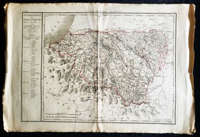
CARTE - PYRENEES ATLANTIQUES / « Département des Basses-Pyré - Lot 22
CARTE - PYRENEES ATLANTIQUES / « Département des Basses-Pyrénées, décrété le 8 février 1790 par l’Assemblée Nationale, divisé en 5 arrondissemens et 40 cantons », P.G. Chanlaire et Veuve Dumez : première carte imprimée de ce département, gravée par François d’Houdan pour l’Atlas National de France, premier atlas des départements français, Années 1800, soulignements aquarellés en rouge et bleu (cuve 71,5 x 52 cm – total 86 x 58 cm)
My orders
Sale information
Sales conditions
Return to catalogue